Linking 2D maps and 3D reality
How can we close the perceptional gap that lies between two dimensional maps and the surrounding three dimensional reality?
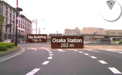
Enkin is a technology aimed at the Google Android platform that provides a location aware map context that switches between a classic top-down satellite view, a 3D aerial and perspective, and a live camera feed from a hand-held device. Objects in the immediate location that are tagged on the map thus become visible in the live camera feed, so you can browse landmarks tagged in the environment around you in real time:
 <p>The navigational paradigm of Enkin is interesting - map views are panned and rotated using input from motion sensors on the device. No scrolling, just physically tilting and turning. This approach to navigation may not be ubiquitous yet, but it is a fairly significant leap forward from the stock standard street maps that seem to dominate today’s GPS market. Enkin could be successful not only because of the more kinesthetic and intuitive navigation, but also because of the limitless possibilities for integrating many different kinds of data into this display. This is exactly the kind of software that Android and other platforms need to help them grow.</p>
<img class=”image” src=/img/fibre-tokyo.jpg” width=”463” height=”360” alt=”Tokyo navigation - Image by Fibre”><p>Working in this emerging information environment will be challenging, and perhaps frightening for many designers. Up until now, most ideas about information overload have centered on communication technologies (such as email) but as this phase shift towards ambient information environments whorls onwards, we are beginning to be faced with a massive storm of information, everywhere we look, everywhere we move. At what point does this environment require new paradigms of user interface design? Is the motif of tagging everyday objects in the visual space around us really the best way to navigate through the latent digital information in that space?</p>
Image Credit - Mapping: An Illustrated Guide to Graphic Navigational Systems, by Roger Fawcett-Tang, William Owen